This week the NYC Department of City Planning announced a study that will help forge a new neighborhood in the Bronx. This followed on the heels of an op-ed by Charles Urstadt arguing in favor of filling in the Harlem River to create new land area. CHPC went into its archives in search of some precedent for this dauntingand for some, mouth-wateringurban planning challenge.
Just two months after humankind first walked on the moon, the master plan for an entirely new New York City neighborhood was published. The Battery Park City Master Development Plan, a 25-page document, laid out the creation of approximately 91 acres of land under the water of the Hudson River. The planners of Battery Park City, like todays city administrators, had one eye fixed on the diversity of the new neighborhood. The Residential Area consists of approximately 79 acres and will contain approximately 14,100 apartments. One-third of these apartments are to be low-income, one-third middle-income, and one-third conventionally financed units. The units will be thoroughly mixed throughout the project to create an economically and racially integrated community without enclaves of high or low rent housing.
Official Planning Criteria form a large part of the Master Plan. First on the list is vehicular circulation, followed by considerations for pedestrians and car parking. (Access to public transit does not receive a mention.) Protection of views of the Hudson receive special protection, particularly unobstructed views of the Hudson River from eye level on Rector Street at Broadway and from eye level on Church Street through the World Trade Center when built.
Interestingly, the plan gets into more detail regarding the square footage of housing and building heights than other topics. Several components of the plan echo the grandiose vision for what Battery Park City would become: The objective will be to contribute toward a pyramidal form for the skyline of Lower Manhattan and to provide a transition between the extreme heights of the World Trade Center towers and the much lower towers in the general vicinity. It calls for the tallest buildings to be 70 or 80 stories near the twin towers.
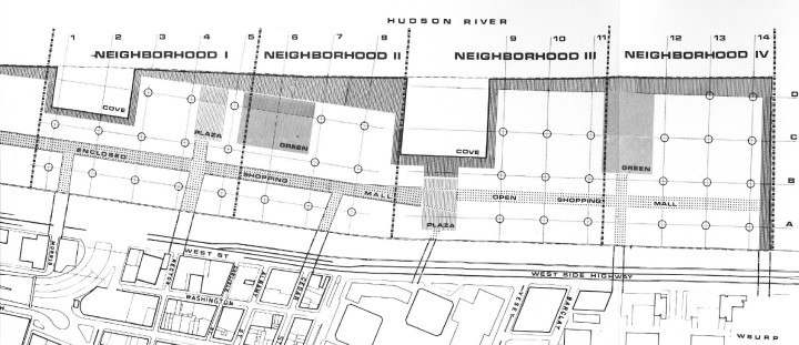
In an ostensible attempt to allow the organic growth of communities on this uber-planned strip of land, planners designated four quadrants of approximately the same size with the names Neighborhood I, Neighborhood II, Neighborhood III, and Neighborhood IV. Each had a prescribed number of square feet to be used for community shopping, neighborhood shopping, and civic facilities. The image you can findheredisplays that particular plan.